
Welcome to U.S. Surveyor FREE Deed Plot
U.S. Surveyor, Nationwide Land Surveyors, call 1-800-TO SURVEY for your FREE Land Survey Quote.
U.S. Surveyor Deed Plot is a FREE online, innovative, easy-to-use, deed description plotting program - designed to provide a graphic representation of deed lines. This program is a great tool for Title companies, real estate attorneys, assessors offices, appraisers, real estate professionals, property owners, propterty buyers, and property managers across the country or even the globe! No surveying or mapping experience necessary! Simply enter the numbers and watch your drawing grow!
After you have completed your Deed Plot and you require a land survey or a division of your property, call the Land Survey Experts at U.S. Surveyor. We are the "Problem Solving Land Surveyors" and we are experts in all types of Properties and Land Surveys, including Nationwide ALTA/Land Title Surveys.
By using the U.S. Surveyor Deed Plot system, you agree to our terms and conditions, and acknowledge that you have read the following documents.
| Legal Notices | Privacy Statement | Computer Requirements | Benefits and Use | Instructions |
LEGAL NOTICE
The drawings created using U.S. Surveyor Deed Plot are not legal surveys, and cannot be used as a substitute for an actual survey under any circumstance. The drawings are simply meant to be used as a tool to provide helpful information such as area, closing distance, and the basic shape and outline of the information contained in a legal description.
U.S. Surveyor in no way guarantees the functionality, accuracy, or acceptable visual result of using this online software. There is no guarantee that the software will operate error free or without interruption, and therefore, there remains a chance that your property may not be able to be plotted using this software. Use of this software is done entirely at the will and risk of the user, with no liability taken by, or given to, U.S. Surveyor for any damages or losses that you or your company may incur as a result of using this software. U.S. Surveyor shall in no even be liable in any case involving the use of this software, whether arising from tort or contract, including loss of data, loss of profits or revenue, cost of cover, or other special, incidental, consequential, or indirect damages arising out of the use or inability to use the website, program, or accompany documentation. These limitations on liability shall apply even in the case that U.S. Surveyor has been notified or advised of the possibility of such damages.
The title and copyright to U.S. Surveyor Deed Plot remain with U.S. Surveyor. Copying of this software, except as specifically authorized by this license and U.S. Surveyor, is expressly forbidden. You may be held legally responsible for any copyright infringement caused or encouraged by your failure to abide by the terms of this license.
Notice to users who are not licensed or registered land surveyors: There are laws in most areas which reserve the production of property boundary survey plats for those individuals who are licensed or registered as a "land surveyor" in their respective locations. In every case, you should be familiar with the laws concerning property boundary surveys in your area and consult with a licensed or registered professional land surveyor as well as an attorney before taking any action based on the results of using U.S. Surveyor Deed Plot software.
Trademarks: Windows is a U.S. registered trademark of Microsoft Corporation or its subsidiaries in the United States and other countries. Celeron, Intel, and Pentium are trademarks or registered trademarks of Intel Corporation or its subsidiaries in the United States and other countries. AutoCAD, is a registered trademark of Autodesk, Inc. in the United States and/or other countries. U.S. Surveyor is a registered trademark, and should not be referenced, reproduced, or used in any way except with the expressed written consent of U.S. Surveyor.
PRIVACY STATEMENT
U.S. Surveyor respects the privacy of our customers and website visitors. We adhere to a strict no-spam policy meaning that we will not send you e-mail for advertising or any other purpose other than important changes or account information that you've requested. If you ever receive an email from us that you are not sure about, simply delete it. We will never ask for your login or account information in an email.
Personal Information: It is our policy that your personal information is private and confidential. Accordingly, the personal information you provide to us is stored in a secure location, and is used only for the purposes for which you provide the information. When you create a drawing on our web-site, your information is stored on a secure server to protect the information from unauthorized access. We will not sell any personal information you provide to us to another entity.
No Computer Tracking: Our web-site is not set up to track, collect or distribute personal information about its visitors. It does not recognize the home server of individuals or their computer ip address. However, our web-site may track statistical information about the number of visitors that come to our web-site. This information is used by us to evaluate the effectiveness of our software, but again, the statistics contain no personal information and cannot be used to gather such information.
Your Consent: By accessing and using our web site and services, including U.S. Surveyor Deed Plot, you consent to the collection and use of information that you have willingly entered as set forth above. Any changes to our Privacy Policy will be posted to the website for your review.
COMPUTER REQUIREMENTS
The recommended system requirements for use of U.S. Surveyor Deed Plot are as follows:
- A pentium or faster computer
- 256 MB Ram or higher
- Microsoft Windows 2000 or higher
- Internet Explorer 4.01 (service pack 2) or higher*
Network Recommendations: After each point is entered, the drawing is refreshed to reflect the new data. Therefore, your experience will be better if your internet connection is at least 256 kb/sec, since the program uses extensive coding for use with its drawing application. A dial up modem should still work, however your wait times for segment additions will substantially increase, with an increased chance of receiving a server time-out error.
NOTE: It is also recommended that your video monitor resolution be set to a minimum of 1024 x 768.
BENEFITS AND USE
A picture is worth a thousand words!
This software was designed not to replace a survey, but to help the user analyze deed descriptions, which can be very cryptic to the untrained eye, and very beneficial to users in a variety of different professions, including title companies, real estate attorneys, assessors offices, appraisers, real estate professionals, property managers, and engineers. The program will provide a drawing of the deed lines based on this description so the user can easily gather needed information. Some of the features and benefits are listed below.
- The drawing lets you visualize the tract more clearly.
- The drawing provides the length of individual lines.
- The drawing provides the acreage for the tract.
- The drawing shows you the closing distance for the tract.
- The software allows users to zoom in and out to see possible problems or smaller areas more clearly.
- The drawings can be printed out.
- The software can handle a variety of curves.
- A data box with all used points is shown on the final drawing when printed.
- The points can be edited later to correct problems, without starting over.
INSTRUCTIONS
This program is designed for non-surveyors. The majority of our users have no experience or training in surveying, engineering, or the plotting of deeds.
Gather up a few sample deeds, and try out our new software - U.S. Surveyor Deed Plot! If you cannot find one, deed descriptions are readily available at most county courthouses, so head there and get a few samples. For the purpose of this example, we will be using the following deed description:
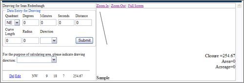
Beginning at a point thence North 09 degrees 18 minutes 07 seconds west 254.67 feet; thence North 68 degrees 09 minutes 48 seconds East 95.80 feet; thence along a curve to the right with a length of 285.22 feet, having a radius of 500.00 feet; thence South 79 degrees 09 minutes 10 seconds East 216.34 feet; thence South 30 degrees 51 minutes 47 seconds West 245.86 feet; thence South 81 degrees 27 minutes 53 seconds West 418.91 feet to the place of beginning.
 STEP 1: The first thing you will need to do is register as a user. Click the register button below and fill out the necessary information. When you submit the info, an account is created for you, and a confirmation e-mail is sent to the address you have provided. This e-mail will contain your password. After you receive this password, come back to this page and enter the information into the boxes below and press the "login" button.
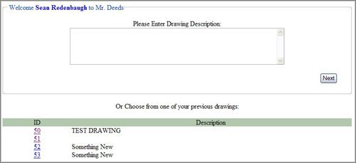
 STEP 2: After logging in, you should see the screen shown on the right (top picture). This screen allows you to see your list of previously created drawings, or start a new one. To start a new drawing, enter a description for it in the box provided and click the "Next" button. If you would like to edit, view, or print a previous drawing, select it by clicking on the ID corresponding to your chosen drawing from the list at the bottom.
STEP 3: For instructional purposes, we'll assume that you've decided to create a new drawing in the previous step, by entering a description for it, and then pressing the "Next" button. If you have done so, you would be taken to a screen that allows you to enter points and view your drawing.
STEP 4: Now you will begin entering your points based on the deed description listed above. The first line is entered from the sentence "Beginning at a point thence North 09 degrees 18 minutes 07 seconds west 254.67 feet;". Deed descriptions can have many different styles, but the one listed above is written in a relatively common form. The quadrant is selected based on the directions listed around the degrees, minutes, and seconds (NE = 1, SE = 2, SW = 3, NW = 4). For this line, the quadrant will be NW. After you select NW from the drop down list, enter the rest of the information for the line and click submit. The page will then refresh and you will see your point listed below in the list, as well as a single line drawn to the right in the box. It should now look like the image shown below.
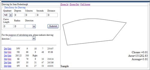
Continue entering in your points from the deed description until you have a completed drawing. Once complete the drawing should look like the completed image shown here. You can now print your drawing or zoom in or out using the zoom links above the drawing. Points in your list can also be edited by clicking "edit" next to your point.
We hope you've enjoyed using this software and found the results helpful. Some deed descriptions may not be plottable using this program, and may result in errors. If this occurs, please contact U.S. Surveyor using the contact link above.
deed plot deed plotter deed plotting deed pro deed software deed description descriptions draw drawings plots
Copyright © - U.S. SURVEYOR - NATIONWIDE LAND SURVEYORS